

REALM33
Directorate of Information Preservation and Archival
Subject Profile – File Extract
Designation: Bermuda Triangle / Devil’s Triangle
Location: North Atlantic Ocean (between Florida, Bermuda, and Puerto Rico)
Approximate Vertices: Miami, FL (25°46′N 80°11′W); Bermuda (32°18′N 64°47′W); San Juan, PR (18°28′N 66°06′W)
First Noted: 1492 (Columbus); Modern Lore Established 1950–1964
Primary Phenomenon: Alleged Unexplained Vessel and Aircraft Disappearances
Controlling Authority: None (International Waters / Natural Geophysical Zone)
Security Classification: Open Source / Persistent Anomalous Region

Fig. 1 – Geographic boundaries of the Bermuda Triangle region
Early History and Establishment
The earliest documented anomalies date to Christopher Columbus’s 1492 voyage, where logs describe compass malfunctions, strange glowing lights on the horizon, and a “great flame of fire” crashing into the sea. Throughout the 19th century, numerous sailing vessels vanished without trace, including the USS Pickering (1800) and HMS Atalanta (1880). The modern mythos crystallized in the 20th century with high-profile incidents: the 1918 disappearance of USS Cyclops with 306 crew, and the 1945 loss of Flight 19 (five TBM Avengers). The term “Bermuda Triangle” was coined in 1964 by Vincent Gaddis in an Argosy magazine article, later popularized by Charles Berlitz’s 1974 bestseller.

Fig. 2 – HMS Atalanta, British training ship lost with 290 crew (1880)
Background
The Bermuda Triangle encompasses roughly 500,000–1,500,000 square miles of open ocean, one of the most heavily trafficked maritime and aerial routes on Earth. Environmental factors include the powerful Gulf Stream current, sudden rogue waves, frequent tropical storms, and pockets of methane hydrate deposits capable of reducing water density. Magnetic variation is minimal in parts of the region, causing compass confusion. Despite claims of disproportionate losses, statistical analyses show disappearance rates comparable to other busy ocean regions when adjusted for traffic volume.

Fig. 3 – False-color NASA image of the Gulf Stream current traversing the region
Known Disappearances
- USS Cyclops (1918) – Colliers ship with 306 aboard; largest non-combat U.S. Navy loss.
- Carroll A. Deering (1921) – Five-masted schooner found aground and abandoned.
- Flight 19 (1945) – Five TBM Avenger torpedo bombers with 14 crew; rescue plane also vanished (13 crew).
- Star Tiger & Star Ariel (1948–1949) – British South American Airways passenger planes, 51 total lost.
- Marine Sulphur Queen (1963) – T2 tanker carrying molten sulphur; 39 crew.
- SS Poet (1980) – Cargo ship with 34 crew; last radio contact routine.
- Additional incidents spanning 1800–present exceed 50 vessels and 20 aircraft with over 1,000 lives.

Fig. 4 – USS Cyclops, vanished with 306 crew in March 1918

Fig. 5 – U.S. Navy TBM Avengers similar to those of Flight 19 (1945)

Fig. 6 – Carroll A. Deering, found deserted off North Carolina (1921)
Notable Connections
Realm33 archives link the region to ancient navigational lore, Plato’s descriptions of Atlantis, and Ignatius Donnelly’s 1882 theories placing the lost continent within the Atlantic. Modern connections include UFO sightings (e.g., Bruce Gernon’s 1970 “electronic fog” encounter), U.S. Navy exercises (Flight 19 originated from NAS Fort Lauderdale), and oceanographic research into methane hydrates and hexagonal cloud formations capable of generating extreme downdrafts.

Fig. 7 – Global distribution of confirmed offshore gas hydrate deposits (USGS, 1996)
Geophysical & Environmental Profile
The region experiences extreme weather variability, with hurricane tracks frequently crossing the area. The Gulf Stream creates rapid current shifts and thermal gradients. Methane hydrate eruptions could theoretically cause sudden buoyancy loss. Hexagonal cloud patterns observed via satellite may produce air bombs exceeding 170 mph. Human factors include navigational errors in an era before GPS, overloaded vessels, and structural failures in early 20th-century designs.
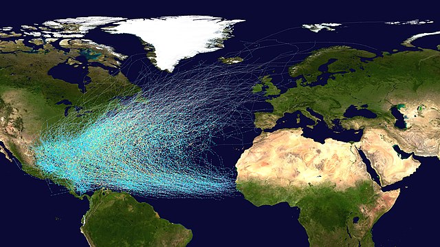
Fig. 8 – Atlantic hurricane tracks (1851–2019); many traverse the Triangle
Anomalous Phenomena & Extradimensional Speculation
Survivor accounts describe sudden dense fog, instrument malfunction, time dilation, and spatial disorientation. Flight 19 radio transcripts indicate pilots believed they were over the Florida Keys while actually far east. Some reports mention green glows or underwater lights. Realm33 assesses the tolerated supernatural narrative as partial cover for conventional hazards while monitoring for genuine non-local effects.
Controversies
- Larry Kusche’s 1975 book demonstrated many incidents were exaggerated, misreported, or occurred outside the region.
- U.S. Coast Guard and Lloyd’s of London state no statistically unusual loss rate compared to traffic volume.
- Claims of insurance premium increases proven false.
- Media sensationalism vs. scientific debunking (rogue waves, human error, weather).
- Ongoing ethical concerns over exploitation of tragedies for paranormal entertainment.
Recent Developments (2026)
Satellite monitoring and improved navigation have reduced unexplained losses. Ocean exploration (NOAA, private expeditions) continues searching for wrecks, with several Flight 19 Avengers located (though identification disputed). Renewed interest follows hexagonal cloud studies and methane research. Realm33 notes persistent cultural impact through documentaries and increased private research into geomagnetic anomalies.
Public Speculations and Linked Narratives
Realm33 archives document enduring theories amplified across media:
- Remnants of Atlantean energy crystals causing electromagnetic disruption.
- Underwater alien base or interdimensional portal activity.
- Time-space warps or wormholes leading to alternate dimensions.
- Magnetic vortex aligned with Earth’s ley lines or ███████ grid.
- Captured vessels used in extraterrestrial or interdimensional experiments.
- Residual effects from Philadelphia Experiment teleportation trials.
While conventional explanations predominate, the persistence of firsthand anomalous reports warrants continued observation.
Status
Region remains active maritime zone with normal risk profile. Cultural phenomenon persists with high public interest. Under continuous Realm33 observation due to “potential non-conventional hazard.” No confirmed supernatural causation. Recommended classification: ANOMALY ZONE – DELTA.
References
- Overview & Map: Wikipedia – Bermuda Triangle (Accessed January 25, 2026)
- Historical Analysis: U.S. Navy Historical Center – The “Bermuda Triangle” (2025)
- Debunking: The Skeptic’s Dictionary – Bermuda Triangle (2024)
- Scientific Explanations: NOAA – What is the Bermuda Triangle? (2025)
- Methane Hydrates: USGS – Gas Hydrates Research (2026)
- Flight 19: Naval Air Station Fort Lauderdale Museum – Flight 19 (2025)
- Cultural Impact: Britannica – Bermuda Triangle (December 2025)
- Visual Documentation: Wikimedia Commons – Bermuda Triangle Category (2026)
Last updated: January 25, 2026.


